Ancestors of a River
- Tara Pozzi
- Aug 20, 2021
- 3 min read
Updated: Sep 10, 2021
Making Channel Migration Visible

Floods are one of the most frequent and destructive natural disasters in the world. Climate scientists predict an increase in the severity and frequency of flood events in the future for many parts of the world. As temperatures rise, the amount of water vapour in the atmosphere increases, exacerbating the potential for extreme rainfall events. At the same time, we see a rising rate of population growth and urbanisation in coastal and inland floodplains. The interaction of these two forms of change drive the need for accurate data about the earth’s surface. This should also inform development activity along these floodplains, such that it accounts for channel migration — how a stream or river moves over time.
Lidar or Light Detection and Ranging images are one such way of making channel migration visible. Lidar provides land planners, floodplain managers, and developers with critical data to accurately predict flood scenarios based on floodplain topography, climate change-informed rainfall and run-off frequency distributions, and flood control structures. Lidar is a laser-based, remote-sensing technology that uses light to gather three-dimensional data points and provide high-resolution details of key topographic features, vegetation, infrastructure, and how they change over broad timescales. While Lidar is a fairly new technology, it has become popular over the last decade for its vast applications including disaster management, development planning, and wildlife conservation.
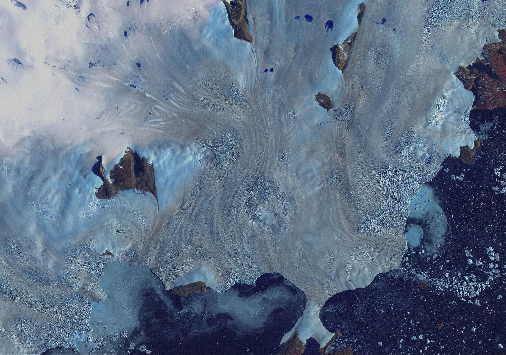
The image below is a satellite image of the Payette River, a major tributary of the Snake River in southwestern Idaho. The image on the right is of the same section of the river created using Lidar. This juxtaposition offers an interesting peek into why we should pay attention to channel migration.
Lidar images of river channels make visible the historic mobility of rivers in the present.
The North fork of the Payette River spans 21 miles from the end of Payette Lake to the start of the Cascade Reservoir in Idaho, USA. Rolling white caps of freshwater from the surrounding Sawtooth and Salmon River Mountains gracefully meander among both the plants and animals it supports. On a summer day, you may find a crew of smiles rafting down a rollercoaster of waves or fishermen casting their line informed by the wisdom of time. Sandy beaches gathered from years of sediment transport buffer the water’s edge. Songbirds sing overhead as a salmon finds its way back home. However, there is a secret history beneath this bustling scene. A secret that can only be seen when the vegetation is scrubbed away, and an ancient maze of channels is revealed.

The Lidar image is taken from a project called LidART, which explores the past as guidance for the future by illuminating historical fluvial features with Lidar data. It therefore offers a more temporal visualisation of the landscape than a standard satellite image, which tends to just capture the present.
This LidART image is a relative elevation model. Sometimes called a ‘height above river model’, it is a way to display the changes in a river that a typical photo wouldn’t show. The darker regions of the channel represent the baseline elevation of the river. As the color fades to white, the elevation increases above the river channel. Apart from its beauty, this imagery provides historical context for the generations of rivers that came before the one we intimately have come to know now. Such a context is critical for understanding our floodplains and potential risks of flooding.
Beyond the practical lessons that can be learned from channel migration, there lies a deeper one about ourselves: rivers are alive and changing, just as we are. While humans have long had intimate and varied relations with rivers, we cannot define or control them. Rather, we need to work with the channels as they migrate over time to ensure our resilience alongside them. The Payette River acts as a muse for us to understand the animated and lively expressions of rivers across the world as we contend with the vast landscape changes that climate change will certainly bring.
As we come to know rivers as mobile beings, we need to learn how to appreciate and engage with them as temporal and active agents. Lidar images of river channels make visible the historic mobility of rivers in the present, reminding us that they will continue to move in the future.
Tara is currently pursuing a PhD in Environmental Policy at UC Davis. She spends her time understanding factors that influence climate change adaptation and decision-making in hazard contexts such as flooding and wildfire. She recently graduated with her Master's in Human-Environment Systems from Boise State University. Previously, Tara worked as a water resource engineer in San Francisco Bay, science communicator in Belize and Ireland, and wilderness therapy instructor in Idaho. In addition to her research, Tara can be found in the backcountry, in her garden, or curating playlists for her community radio station.


Comments